
Explore
In an era of rising climate uncertainty, traditional risk models are no longer enough. The old methods of assessing business continuity or infrastructure exposure, often built on historical weather averages and insurance records, are being rapidly outpaced by the scale and speed of climate change. Today, the question is no longer whether climate-related disruptions will occur, but where, how intensely, and to whom.
The need to map climate vulnerability has never been more urgent. Fortunately, recent advances in satellite technology, artificial intelligence (AI), and geospatial analytics are transforming how we identify, quantify, and respond to climate risks. From drought prediction in rural India to flood forecasting in Southeast Asia and wildfire modeling in California, data-driven climate intelligence is enabling policymakers, businesses, and communities to move from reactive responses to proactive planning.
Climate vulnerability is a function of three interrelated factors: exposure to climate hazards, sensitivity of systems and populations, and adaptive capacity. A coastal city facing sea-level rise may be highly exposed, but whether it’s also highly vulnerable depends on the resilience of its infrastructure, the capacity of its government, and the socioeconomic conditions of its residents.
Mapping this vulnerability requires integrating vast and varied datasets—temperature trends, rainfall variability, floodplains, crop cycles, socioeconomic indicators, urban development, and more. Traditional models often lacked this granularity or timeliness. But the data revolution is rapidly filling that gap.
Satellites have emerged as a critical tool for climate risk mapping. Agencies like NASA, ESA, and ISRO now provide high-resolution Earth observation data on land use, vegetation cover, water stress, glacier melt, and atmospheric conditions. With revisit rates measured in days (or even hours, in the case of newer constellations), satellites can detect early signs of drought, track the extent of wildfires, or monitor coastal erosion in near-real time.
In India, for instance, remote sensing is being used to monitor groundwater depletion, predict agricultural yield variability, and assess flood risk across the Ganga basin. Urban planners in Chennai and Mumbai are using satellite imagery to overlay informal housing with flood-prone zones, helping guide both infrastructure investment and emergency preparedness.
What once required extensive field surveys can now be done in a matter of days, at scale. This shift not only enhances accuracy, it democratizes access to climate intelligence, making it available even to local governments and small enterprises.
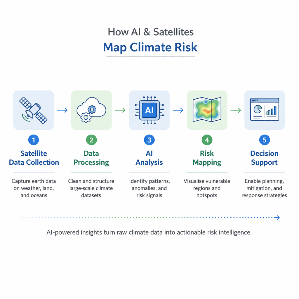
While satellites provide the "what" and "where," AI delivers the "why" and "what next." Machine learning models are now trained to detect patterns in climate and environmental data that humans might overlook. These models can correlate rainfall anomalies with disease outbreaks, link heatwave patterns to power grid failures, or forecast flood impact based on terrain and urban density.
One of the most promising developments is downscaled climate modeling. Global climate models (GCMs) operate at a coarse resolution, making them less useful for regional planning. AI helps "downscale" these models—translating global projections into district-level insights. This allows a state government in Assam or Maharashtra to estimate how climate scenarios affect local crops, water availability, or transportation networks.
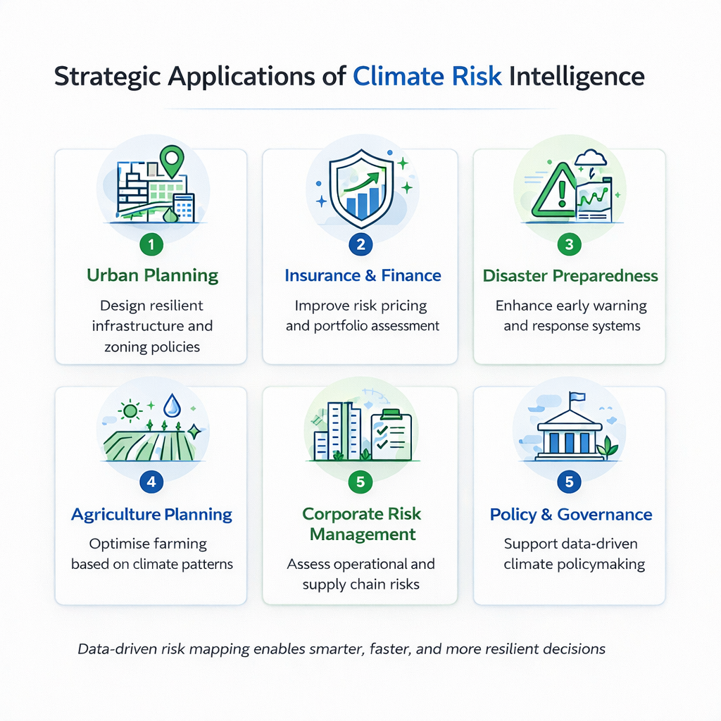
In the insurance sector, AI is being used to develop parametric insurance products, where payouts are triggered automatically by satellite-observed weather events. This not only reduces fraud and delays but also ensures faster support to farmers and communities affected by disasters.
Across the globe, organizations are using geospatial and AI tools to make climate-smart decisions. Municipalities are mapping climate vulnerability to prioritize heat-resilient housing and green cover in low-income areas. Banks are using satellite data to assess the flood exposure of their real estate-backed loan portfolios. Agritech firms are combining weather forecasts, satellite imagery, and soil data to optimize crop insurance and advisory.
In India, the National Remote Sensing Centre (NRSC) is collaborating with multiple ministries to integrate climate vulnerability maps into policy and planning. Private platforms like Google’s Environmental Insights Explorer, SatSure, and Mapbox India are making high-resolution climate data available for urban development, disaster risk reduction, and ESG reporting.
While the promise of data-driven climate risk assessment is enormous, it’s not without limitations. Access to data remains uneven. Much of the high-quality satellite data is proprietary, expensive, or locked in technical formats. AI models, too, are only as good as the training data they’re fed, and may reproduce biases or errors if not carefully monitored.
Moreover, data alone doesn’t drive action. Without institutional capacity, community engagement, and governance accountability, even the most accurate climate maps can sit unused. Integrating data into real decision-making, budgets, building codes, investment plans, requires bridging the gap between climate science, policy, and finance.
As powerful as satellite data and AI-driven models are, the real challenge lies in converting climate intelligence into boardroom strategy, actionable data-driven insights, and financial decisions. Many organizations today face three critical barriers:
This is where the PG Executive Program in Net Zero Strategy & Sustainability Leadership, jointly offered by IIM Kashipur and evACAD, becomes highly relevant.
Designed for mid- to senior-level professionals, the program equips leaders with the tools to connect climate science with business, finance, and governance.
For professionals in energy, finance, policy, or sustainability, this program is not just an academic credential; it’s a career accelerator. It empowers leaders to go beyond understanding climate risk maps to designing the policies, investments, and business models that turn resilience into a competitive advantage.
In the age of climate volatility, knowing where you're vulnerable is the first step to becoming resilient. The convergence of satellites, AI, and open data is making it possible to see the future, not in abstract models, but in real-time maps and localized projections. The question is no longer whether we can predict climate risk; it’s whether we’ll act on that intelligence. For countries like India, where climate impacts intersect with poverty, informality, and infrastructure gaps, the need for predictive, high-resolution climate data is not a luxury; it’s a development necessity.
As the tools improve and the data deepens, one thing becomes clear: the map is no longer the territory, it’s the future.


.webp)
.jpg)